The geometry of seacoasts are often used as an introductory archetype of fractal morphology in nature. To our knowledge, there are no models trying to explain why coasts are fractal, and how such fractal geometry is generated.
What is a fractal?
A fractal is a geometrical shape, or better a class of geometrical shapes. They are quite widespread in nature, maybe more than triangles, squares, cubes or spheres. Especially biological objects have fractal shapes, as for instance…
 |
 |
 |
 |
See here for a brief tutorial on fractals and fractal dimensions.
Coastal systems
“The coast is simply where the land meets the sea.” from Coastal Systems by Simon K. Haslett (Routledge, Taylor and Francis, London 2000)
“As a matter of some urgency, researchers concerned with coastal evolution should consider the alternative models, even if there are few supporting data. The ideas of non-linear response, stochastic developement, deterministic chaos, catastrophism and criticality all deserve investigation.” (From “Coastal Evolution. Late Quaternary shoreline morphodynamics” Ed. R.W.G.Carter and C.D. Woodrffe Cambridge University Press 1994.)
A simple model of rocky coasts erosion
We propose a minimal model for the formation of rocky coast morphology. This model bears on the reciprocal evolution of the erosion power and the topography of the coast submitted to that erosion: The more irregularly eroded the coast is, the weaker the average sea erosion power. This retroaction leads to the spontaneous formation of a fractal seacoast.

The erosion of rocky coasts is the product of marine and atmospheric causes. There exist many different erosion processes: wave quarrying, abrasion, wetting and drying, frost shattering, thermal expansion, salt water corrosion, carbonation, hydrolysis. A simplified picture is used here by assuming that the different processes can be separated into two categories: “rapid” mechanical erosion (namely wave quarrying) and “slow” chemical weakening. The justification is that mechanical erosion generally occurs rapidly, mainly during storms, after rock has been altered and weakened by the slow weathering processes.
Modelling the sea
The sea, together with the coast, is considered to constitute a resonator. It is assumed that there exists a given average power of the waves P0. The “force” acting on the unitary length of the coast is measured by the square of the wave amplitude. This wave amplitude is related to the input wave power, and their ratio is the quality factor Q, which measure the damping: the smaller the quality factor, the stronger the damping of the sea-waves.
There are several causes of sea-waves damping. Different loss mechanisms occur independently.
The numerical and experimental studies of fractal acoustical cavities have shown that the viscous damping increases roughly proportionally to the perimeter of the cavity, leading to the idea that a mathematical fractal cavity should be totally damped. Therefore, one can, in first approximation, assume that the contribute to the quality factor Q due to coast morphology is is proportional to the inverse of the coast perimeter length Lp(t) (it depends on time during the erosion process).
In other words, the sea is thought to exert an homogeneous erosion force f(t) on each coast element which decrease when the coast perimeter increase. The precise law is not so important, however we used:

where f0 is a constant related to the initial value of f(t=0) and g is a parameter which measures the the importance of coast dissipation with respect to other mechanisms (e.g. bulk viscous damping).
Modelling the earth
The “resisting” earth is represented by a square lattice of linear size L0. A random number xi extracted from a flat probability distribution in the interval [0,1], is assigned to each earth site i independently of the other sites. This number is thought to represent the random lithology of the site i. Each site then represents a small portion of the earth that may be considered lithologically uniform. The erosion model must also take into account that when a site is surrounded by the sea it is submitted to a larger erosion and its resistance is relatively weakened as compared with a coast site surrounded by earth or other coast sites.
To model this effect we impose the corresponding rule: a site has a resistance to erosion ri given by ri = xi^niwhere ni is the number of first neighbors occupied by the sea if ni is smaller than (z-1), z being the coordination number of the lattice. If ni >= (z-1) then ri = 0. On a square lattice where z = 4 this means that sites surrounded by three solid sites have a resistance ri = xi. If in contact with 2 sea sites the resistance is ri = xi^2. If the site i is in contact with 3 or 4 sea sites, it has a zero resistance to erosion. This is the way to introduce a link between the mechanical stability of a site and its environment, sea or earth. An example is shown in Fig. 2. The erosion rule itself, illustrated in Fig. 3, is simple. At time t, all coast sites with ri <f(t) are eroded and Lp(t) and then f(t) are updated and the earth sites which are in contact with the sea have their resistances updated. One can see in the figure below that, from one step to the next some sites have been eroded because they present a “weak lithology” while some “strong lithology” sites are eroded due to their small mechanical stability. The above rule then takes care of a decreased strength for sites which are partially or totally surrounded by water. This mechanism reinforces the mechanical stability of the coast in the sense that flat micro zones are statistically helped to resist. On the opposite the existence of earth filaments is eliminated.

Caption: How the sites resistances to erosion are linked to their lithology and to their environment. A site with 3 or 4 sea neighbours have no resistance. A site with lithology xi with 2 earth neighbours has a resistance ri = xi*xi. A site with 3 earth neigbors has a resistance equal to its lithology ri = xi. Left: lithology distribution xi (bold numbers) and corresponding resistences ri (tiny numbers). Right: After the corrosion action of the sea for an eroding power of 0.5.
“Rapid” erosive dynamics
We study iteratively the time evolution of the morphology of the coast, of the eroding ”strength” of the waves and of the progressive hardening of the coast by successive elimination of the weakest parts by erosion. As the coast-line length increases, the mechanical eroding force per unitary length exerted by the sea is decreased to a point where the coast is strong enough to resist further erosion.
 Start of the “rapid” mechanical erosion process. |
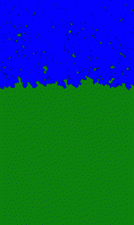 During the “rapid” mechanical erosion process. |
 At the end of the “rapid” mechanical erosion process. |
Caption: The erosion front keeps quite smooth at the beginning of the dynamics and gets then progressively roughens. On average, starting from a flat coast, Lp(t) increases with time and the sea force becomes weaker. During the process, finite clusters are detached from the “infinite” earth, i.e. islands are created by the erosion process. Consequently, at any time, the total perimeter is constituted by both the surface of islands and the surface of the “infinite” earth , which will is the coast-line. This coast-line becomes very irregular only towards the end of the dynamics.
Sea erosive strength

Caption: The erosive stregth of the sea decreases during the erosion process, due to the damping by the coastline geometry.
Fractal dimension

Caption: Box-counting measure of the fractal dimension for the final costal geometry, the straight line correspond to a fractal dimension of 4/3.
Coast width

Caption: Power law scaling of the average coastal width as a function of the parameter g (gradient).
Universality and percolation
The model belongs to the universality class of Gradient Percolation, for what concern the fractal dimension of the final geometry of the coastline and the exponents characterizing the scaling properties of the quantities with respect to the gradient parameter g.
Gradient Percolation

Caption: A representation of the gradient percolation model.
Conclusions
In summary, this work has presented a minimal model for rocky coast formation which bears on the reciprocal evolution of the erosion power and the topography of the coast submitted to that erosion: The more irregular the coast, the weaker the sea-waves and the sea erosion power. This retroaction leads to the spontaneous formation of a fractal sea-coast with a fractal dimension Df = 4/3. The fractal geometry plays the role of a morphological attractor. This means that whatever its initial shape, a rocky shore will end fractal if submitted to such a type of erosion, forgetting its initial morphology. At the same time, all the weak components of the sea-shore are eroded, determining a complex hardening of the remaining shore. This model reproduces at least qualitatively some of the fundamental features of real coasts using only simple ingredients.
Some pictures and nice animations
- An artistic view of our model by Jean-Francois Colonna
Further readings
- Bird, Eric C. F. Coasts, (Van Nostrand Rheinhold Co., New York, 1984).
- Bird Eric C. F. and Schwartz M. L. (eds), The World Coastline (Van Nostrand Rheinhold Co., New York, 1985).
- Mandelbrot B. B., How long is the coast of Britain? Statistical self-similarity and fractional dimension, Science, 155, 636 (1967)
- Mandelbrot B. B., The Fractal Geometry of Nature (Freeman, New York, 1982).
- De Vriend, H.J., Capobianco, M., Chesher, T., De Swart, H.E., Latteux, B. and Stive, M.J.F., Long-term modeling of coastal morphology, Coastal Engineering, 31, n. 1-3, pp 225-269 (1993).
- Sapoval B., Haeberlé O., and Russ S., Acoustical properties of irregular and fractal cavities, J. Acoust. Soc. Am., 102, 2014-2019 (1997).
- Hébert B., Sapoval B., and Russ S., Experimental study of a fractal acoustic cavity, J. Acoust. Soc. Am., 105, 1567 (1999).
- Sapoval B., Fractals (Aditech, Paris, 1989)
- Shore protection manual (Coastal Engineering Research Center, Department of the Army Waterways Experiment Station, Vicksburg, Mississippi, vol 2, ch. 6, 7, 1984)
- Davis, R.A., Jr, 1986, Oceanography – An Introduction to the Marine Environment, Wm C Brown Publ., 432 pp.
- Stauffer D. and Aharony A., Introduction to Percolation Theory (Taylor & Francis, London, 1991).
- Balasz L., Corrosion front roughening in two-dimensional pitting of aluminum thin layers, Phys. Rev. E 54, 1183-1189 (1996).
- Sapoval B., Santra S. B., and Barboux Ph., Fractal interfaces in the self-stabilized etching of random systems, Europhys. Lett., 41, 297-302 (1998).
- Gabrielli A., Baldassari A., and Sapoval B., Surface Hardening and Self-Organized Fractality Through Etching of Random Solids, Phys. Rev. E 62, 3103, (2000).
- K. J. Falconer, Fractal Geometry: Mathematical Foundations and Applications (J. Wiley, New York, 1990).
- Grossman T. and Aharony A., Accessible external perimeters of percolation clusters, J. Phys. A, 20, L1193-L1201 (1987).
- J. Feder, Fractals, (Plenum Press, New York, 1988).
- B. Sapoval, M. Rosso and J. F. Gouyet, The fractal nature of a diffusion front and relation to percolation, J. Phys. Lett. (Paris), 46, L149-156 (1985).
- Gabrielli A., Munoz M. A., and Sapoval B., Field theory of self-organized fractal etching, Phys. Rev. E, 64, 016108-1,-8, (2001).
Links
- The Coastline Extractor http://rimmer.ngdc.noaa.gov/coast/getcoast.html
- Fractal Erosion http://www.forester.net/ecm_0205_fractal.html
- Jean-Francois Colonna http://www.lactamme.polytechnique.fr/
- Barton C., http://coastal.er.usgs.gov/barton/web
- Greve C. http://www.usyd.edu.au/su/marine/lect/imsb/greve-l11.html
- Barton C., http://coastal.er.usgs.gov/barton/pubs/fractalmap.pdf
- Barton C., http://coastal.er.usgs.gov/barton/pubs/coastal.pdf